Population
12,764
Coordinates
57.8675° N, 152.8822° W
Location
252 Air Miles SW of Anchorage
Land Area: 6.3 square miles (City of Kodiak)
Water Area: 3.7 square miles
The City of Kodiak is nestled on the northeastern side of the second largest island in the United States (Kodiak). The Kodiak Road System is comprised of approximately 87 miles of state-owned roads, with end points at White Sands Beach, Fossil Beach in Pasagshak, and Anton Larsen Bay. The City of Kodiak is the most densely populated community on the Road System though populations also exist out of city limits in Bells Flats, Coast Guard neighborhoods, Pasagshak, Chiniak, and remote locations in between.
History & Culture
The first people (Alutiiq/Sugpiaq) arrived on Kodiak Island more than 7,500 years ago via “skin boats” (1) along the Aleutian Chain. The Alutiiq/Sugpiaq people thrived on Kodiak Island for thousands of years before Russian contact in the late 1700s, when Russian fur hunters, traders, and explorers established the first permanent Russian settlement in Alaska on Kodiak. This settlement acted as a commercial port and the first capital of Russian America.2
Kodiak has a long history of natural disasters as well, with Mount Novarupta erupting in 1912, covering the City of Kodiak in Ash3, as well as the “Great Alaska” earthquake in 1964 that triggered devastating tsunamis to the island, leveling out downtown infrastructure.4
The City of Kodiak saw a boom in population during World War II as the island acted as a perfect strategic location for the North Pacific. The United States Navy built a large base which still stands today, now as the largest United States Coast Guard Base.5 Before WW II, Kodiak was a fishing community of approximately 400 people.6
Governance & Contact
City of Kodiak
2nd class city, incorporated in 1940
6-member City Council
907-486-8636
Kodiak Island Borough
2nd class borough, incorporated in 1963
7 member Assembly
907-486-9300
The City of Kodiak was incorporated in 1940, 77 years after the United States purchased Alaska from Russia and nearly 20 years before Alaska became the 49th state. In 1965 a City Charter was adopted and signed so that Kodiak could operate as a “Council-Manager” form of government.7
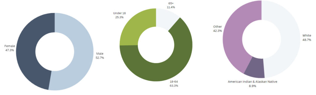
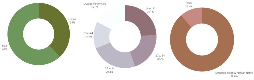
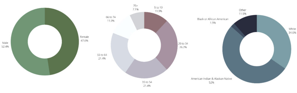
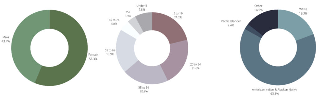
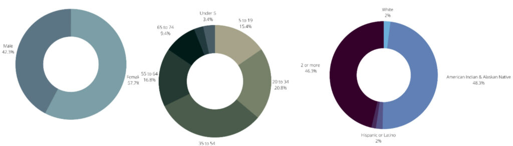
Demographics – Population by Sex, Age, and Ethnicity (from left to right)
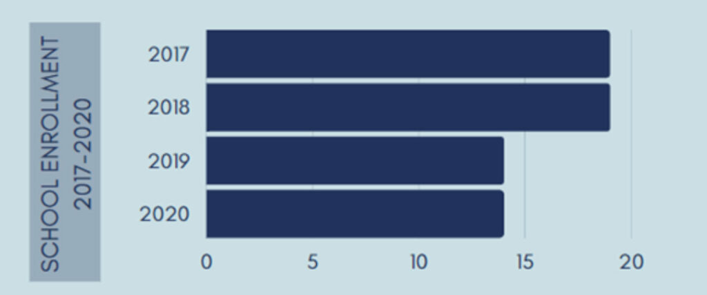
Education
| Preschools | Elementary Schools | Middle Schools | High Schools | Higher Education |
| Akteach | Akteach | Akteach | Akteach | Kodiak Community College |
| _ | Chiniak School | Chiniak School | Chiniak School | |
| KIBSD Early Childhood Services | East Elementary | Kodiak Middle School | Kodiak High School | |
| Alutiingcut Childcare Center | Main Elementary | Kodiak Christian School | ||
| Child Development Center – CG Base | Peterson Elementary | _ | ||
| Kodiak Christian School | North Star Elementary | The Rock Education Group | ||
| The Rock Education Group | Kodiak Christian School | |||
| _ | The Rock Education Group | |||
| RurAL CAP-Headstart | _ |
Transportation – Only accessible by boat or plane
Air
Benny Benson State Airport is a public and military use airport comprised of 3 asphalt-paved runways, all measuring between 5,000 – 7,500 feet long.8 Alaska Airlines is the only commercially owned airline that flies into Kodiak offering flights to and from Anchorage (approximately a one-hour flight). Small planes also operate from the state airport, offering flights from the City of Kodiak to all communities off of the Road System. Kodiak also features a municipal airport with a 2,883-foot paved runway. There are floatplane facilities at Lily Lake and Trident Basin on Near Island.
Water
The Alaska Marine Highway, operating the M/V Tustumena and M/V Kennicott connects Kodiak with Port Lions, Old Harbor, Ouzinkie, and _ the Alaska mainland. It _provides passenger and car transport service year-round. Two-all cargo carriers and one scheduled intra-island carrier ship_ also serve Kodiak to provide food, provisions, and supplies.9
Employment & Businesses
600 Active Business Licenses10
$91,138 Median household income11
5% Unemployed12
7.5% Living below poverty
7% Sales tax (city limits)
*10.25 Property tax mills13
5% Bed tax14
Kodiak is home to the largest fishing fleet in the state of Alaska with 650 slips _in the Kodiak Municipal Harbor, which is owned by the City of Kodiak. Kodiak is_ one of the top ports in the world, _as commercial fishing is a dominant part of the economy.15 Additionally, you can also find the largest U.S. Coast Guard Air Station in Kodiak, making government jobs a large part of the workforce. Other sectors like retail, manufacturing, and tourism are important parts of the Kodiak economy as well.16
*Service Districts and property taxes based on service needs.
Community Energy Sources & Use
Utility Provider: Kodiak Electric Association
Sources of Energy: Hydropower, Wind,Diesel
Gas Vendor: Petro Marine / Petro 49
Heating Oil: Petro Marine / North Pacific Fuel
Capital Improvement Projects (CIP) List FY2317
| Project | Estimated Cost | Funds Needed |
| Hospital Facility Sterilizer and Boiler Replacement | $1,000,000 | $1,000,000 |
| Kodiak Community Health Center Expansion Design | $25,850,000 | $1,200,000 |
| Ouzinkie Electrical Distribution System | $2,500,000 | $2,500,000 |
| City of Larsen Bay Water Distribution Lines | $1,700,000 | $1,700,000 |
| Old Harbor Septic Tank Replacement | $100,000 | $100,000 |
| Service Area Road Improvements and Paving | $10,000,000 | $9,000,000 |
| Drainage Improvements for Chiniak Highway and Sargent Creek Intersection | $2,500,000 | $2,500,000 |
| Port Lions State Route Improvement Project | $1,200,000 | $1,200,000 |
| School Roof Evaluation and Design | $100,000 | $100,000 |
| Safe Pathways to North Star Elementary School | $2,000,000 | $2,000,000 |
| Akhiok School HVAC Controls Replacement | $300,000 | $300,000 |
| Sargent Creek Community Playground & Basketball Court | $300,000 | $148,000 |
| Mill Bay Beach Access and Recreation Upgrade | $500,000 | $500,000 |
| Anton Larsen Bay Road Extension to Ice Free Water | $10,450,000 | $10,000,000 |
References
1. Alaska Native Heritage Center | Alaska History and Cultural Studies (lpsd.com)
2. Alutiiq People – Alutiiq Museum and Archaeological Repository
3. https://www.nps.gov/articles/aps-v11-i1-c10.htm
4. https://vilda.alaska.edu/digital/collection/cdmg23/id/600/rec/3 (Visual of downtown from the Museum to support)
5. https://koc.alaska.edu/about/community/
6. https://koc.alaska.edu/about/community/
7. https://www.city.kodiak.ak.us/community
8. https://dot.alaska.gov/sereg/projects/kodiak-airport/20210422_Kodiak%20Airport_Presentation.pdf
9. https://dot.alaska.gov/amhs/communities.shtml
10. https://www.city.kodiak.ak.us/finance/page/active-business-licenses
11. https://www.census.gov/quickfacts/fact/table/kodiakislandboroughalaska/INC110222#INC110222
12. https://live.laborstats.alaska.gov/data-pages/labor-force-area-data?s=18&a=0
13. https://www.kodiakak.us/DocumentCenter/View/394/Mill-Rates?bidId=
14. https://www.kodiakak.us/285/Transient-Accommodations-Tax#:~:text=The%20Borough%20collects%20a%205,within%20the%20Kodiak%20Island%20Borough
15.https://www.city.kodiak.ak.us/ph
16. https://datausa.io/profile/geo/kodiak-ak#:~:text=Median%20household%20income%20in%20Kodiak,values%20of%20%2470%2C893%20and%20%2436%2C979
17. https://www.kodiakak.us/DocumentCenter/View/10718/KIB-State-Legislative-Capital-Improvement-Projects-Priority-List?bidId
Population1
63
Coordinates2
56.9456° N, 154.1703° W
Location
90 Miles SW of Kodiak, 340 Miles SW of Anchorage
Land Area: 7.8 square miles
Water Area: 2.4 square miles
Akhiok is located on the southwest end of Alitak Bay, between Kemph Bay and Moser Bay. The terrain surrounding Akhiok is made up of low hills and a moist tundra-like valley. There are few tall brush areas and trees, and some stands of alder are present. Akhiok is surrounded by land owned by the Akhiok-Kaguyak Native Corporation and is within the Kodiak National Wildlife Refuge. The area is rich in wildlife and marine life, while the original village site on the Aliulik Peninsula has a high brown bear density and ancient Alutiiq petroglyphs are preserved near the present village.
History & Culture
The original village of Akhiok was located near Humpy Cove, on the eastern side of Alitak Bay, and was originally a sea otter hunting settlement. The village, called Kashukugniut, was occupied by the Russians in the early 19th century. The name Akhiok was reported in the 1880 census. In 1881, residents from the old village relocated to the present site at the south end of Kodiak Island at Alitak Bay. A post office was established in 1933 and remained open until 1945. The village was renamed Alitak during World War I by the post office to avoid confusion with a village near Bethel named Akiak. The name was later changed back to Akhiok. With the decline of the sea otter industry, however, the village became oriented primarily toward fishing. Following the 1964 earthquake and tsunami, families from the village of Kaguyak were relocated to Akhiok. The majority of the community are descendants of Kodiak Archipelago’s Sugpiaq/Alutiiq peoples. Residents are proud of their heritage and traditions of respect for the land and marine resources. Subsistence is an important part of the community’s culture and well-being. Children are taught from an early age how to hunt, fish, dig for clams, pick berries, and gather medicinal plants. Akhiok residents consider halibut, flounder, and cod as primary subsistence fish resources as well as salmon and trout. In addition, all varieties of clams are utilized, as are crab and shrimp. Marine mammals of subsistence importance include seals, sea otters, and sea lions. The Kodiak brown bear and the Sitka black-tail deer are both popular for sport hunting and are essential sources of subsistence food for local residents.3
Governance & Contact
City of Akhiok
2nd class city, incorporated in 1974
7-member City Council
City_of_akhiok10@yahoo.com
Native Village of Akhiok
7 members of Tribal Council
donene89@yahoo.com
Kaguyak Tribal Council
9 enrolled Tribal members
PO Box 5078, Akhiok, AK 99615
Pamodo_98@yahoo.com
Two federally recognized Tribal councils, Native Village of Akhiok and Kaguyak Village, are jointly eligible to administer a variety of federal programs, including local health care, employment assistance, and other social services. They assign their federal contracting authority to the Kodiak Area Native Association (KANA), which then administers many of these programs and provides essential services. The City levies no property or sales taxes, and most municipal funds come from service charges and state-shared revenue. The City and Tribal Councils provide services including street maintenance, electricity and fuel distribution, water and sewer, police and emergency response services, a Culture Center, airstrip maintenance, and solid waste disposal.
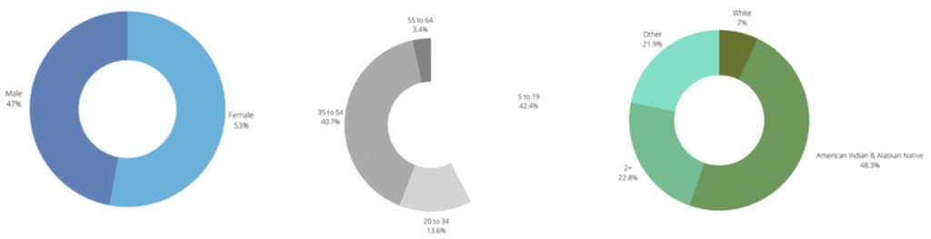
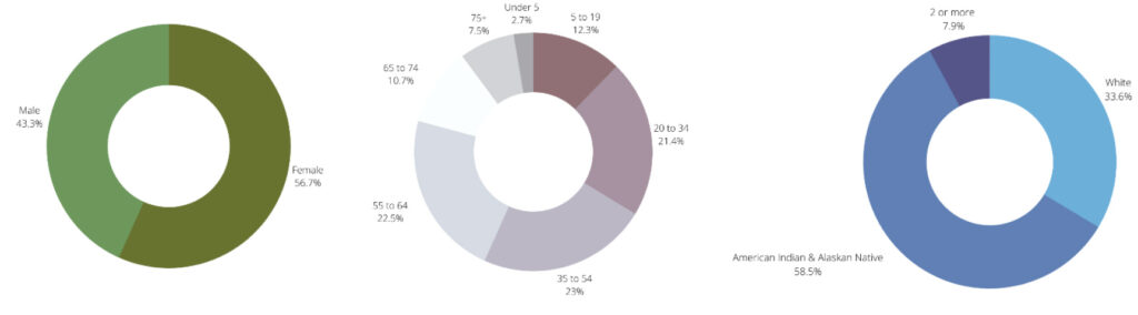
Demographics4 – Population by Sex, Age, and Ethnicity (from left to right)
Education5
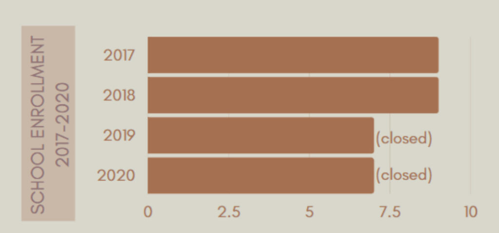
Akhiok School
Kodiak Island Borough School District
Transportation – Only accessible by boat or plane
Air
Small gravel airstrip, in need of an expansion to accommodate larger aircrafts.
Island Air Service provides flights 3 times per week.6
Water
No boat harbor; no dock.
Employment & Businesses
3 Business License Holders
$27,500 Median household income
39% / 66% Year-round / Seasonal unemployed
20.5% Living below poverty
3% Sales tax
10.75 Property tax mills
Akhiok’s economy is based on a mixture of commercial fishing and subsistence harvest activities, with some commercial tourism focused on sport fishing and hunting. Much of the community’s cash flow also comes from public-sector employment. In recent years, commercial fishing activities have been adversely affected by several factors, including limited entry and individual fishing quotas, the Exxon Valdez oil spill of 1989, and a decline in fish prices. The community has one lodge that provides some employment opportunities for residents who provide fishing and hunting guide services. The nearby Alitak fish processing plant does not employ Akhiok residents, however the community has relied on fuel and delivery services through Alitak Cannery for man years. In 2024, OBI Seafoods announced that the Alitak Cannery will not purchase commercially caught salmon from set net site operators, and limited purchase from the seining fleet, marking the end of an era.
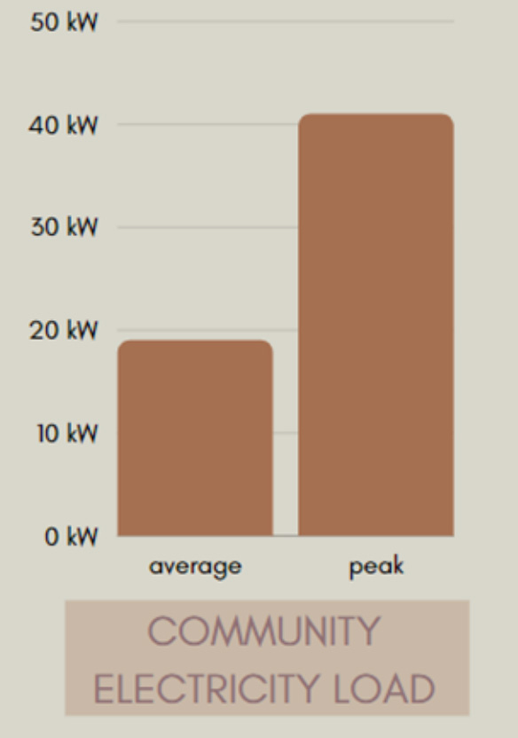
Community Energy Sources & Use
Utility Provider: Akhiok/Kaguyak Electric
Sources of Energy: Diesel
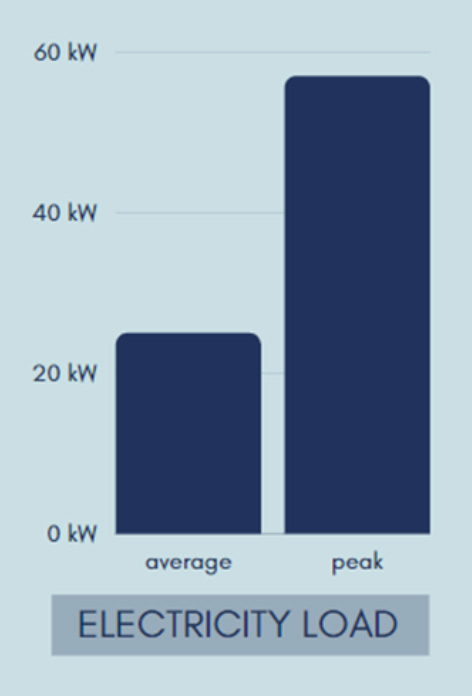
Electrical Generation Capacity: 3654 kWh Diesel / 3 Diesel generators
PCE Status: Active ($0.13/kWh)
| Electric Customers | Annual Fuel UsE (Gallons) |
| 22 Residential | 35,340 Electric |
| 4 Community Facilities | 27,357 Space Heating |
| 1 Government | 7,317 Transportation |
| 5 Commercial |
Community Energy Priorities
- Maintenance and Efficiency of Community Transportation Infrastructure:
a. Construction of a fuel pier with dolphins and marine header
b. Feasibility of road to Alitak Cannery
c. Acquire fuel truck to move fuel from tank farm to power house - Develop Local Energy Generation:
a. Solar: test feasibility of cost/benefit of solar integration - Maintenance and efficiency of public buildings
a. Feasibility of energy efficiency upgrades to public buildings - Maintenance and efficiency of residential buildings
a. Expressed need for new, energy-efficient homes. Some homes are so old that they shouldn’t be retrofitted; they need to be retired.
Capital Improvement Projects (CIP) List FY21
| Estimated Cost | Project Name |
| $125,000 | School Heat Recovery |
| Unknown | Fuel Dolphin |
| Unknown | Landfill Relocation |
| 1 Million | Renewable Energy Generation Integration |
References
1. https://www.census.gov/
2. https://www.bia.gov/
3. https://aki-kodiak.com/our-lands/tourism/
4. https://www.census.gov/
5. https://education.alaska.gov/
6. https://www.flyadq.com/
Population1
27
Coordinates2
57.5719° N, 154.4556° W
Location
88 Miles SW of Kodiak, 301 Miles SW of Anchorage
Land Area: 55.4 square miles
Water Area: 2.4 square miles
The community of Karluk is nestled beside the Karluk River at the Karluk River mouth, facing the Shelikof Strait on the western end of Kodiak Island. The village is surrounded by low-lying mountains, moist tundra, and rivers and streams. _ Kodiak National Wildlife Refuge encircles the Village of Karluk. The Karluk River drainage has one of the highest densest populations of bears in the world; 180 to 200 Kodiak bears are known to use the drainage.
History & Culture
The area spanning from Karluk Lake to the Karluk River mouth is thought to have been inhabited by Sugpiaq/Alutiiq peoples for more than 7,000 years. There are over 46 archaeological sites that show evidence of Alutiiq peoples inhabiting the area. Russian hunters, drawn to the abundant salmon run in the Karluk River, established a trading post as the first permanent community at Karluk in 1786. In 1878, the Karluk Packing Company cannery was built in Karluk, the first cannery on Kodiak. By the late 1800s, at least 5 canneries were operating out of Karluk. The population had risen to over 1,000 residents, making it the third-largest community in Alaska at the time. The Karluk canneries were producing most of the sockeye salmon that came out of Alaska, and the town was home to the world’s largest cannery. Overfishing eventually decreased the salmon population and the canneries closed down in the 1930s. The Karluk Russian Orthodox church was built in 1888 and continues to be a key part of the community. Historically, the community was split across two sites, one on either side of the spit at the entrance to the lagoon. “Old” Karluk lies on the northern side with “new” Karluk on the southern side. New Karluk is the residential core of the community, and is home to all but three or four families. The village council relocated the community to its present site after a severe storm in January 1978.
Governance & Contact
Karluk, Census-Designated Place
Unincorporated City
No municipal government structure
Karluk Indian Reorganization
Act (IRA) Tribal Council
7 members of Tribal Council
PO Box 22 Karluk, AK 99608
907-241-2218
Karluk is an unincorporated community, with no municipal government structure. Most community activities are governed by the Karluk Tribal Council, the federally recognized tribe and official Tribal governing body. The Tribe is eligible to administer a variety of federal programs. It currently contracts with the Kodiak Area Native Association for elder meal services. Because Karluk is not a second-class city, it is not eligible for the same Borough or state assistance as other outlying communities in the Borough.
Demographics3 – Population by Sex, Age, and Ethnicity (from left to right)
Education4
Karluk School
Kodiak Island Borough School District
Air
State of Alaska-owned 2,400-foot gravel airstrip
One flight per day (year-round, weather permitting) between Karluk and Kodiak through Island Air Services
Water
Seaplane base at Karluk Lake
Employment & Businesses
3 Business License Holders
$19,500 Median household
28% Unemployed
25% Living below poverty
0% Sales tax
10.75 Property tax mills
Hunting and guide services provide some seasonal employment. Most residents rely heavily on the subsistence economy to supplement their diets. Most available fish and wildlife species are harvested, including shellfish, finfish, waterfowl, small and big game, and marine mammals.
Community Energy Sources & Use
Utility Provider: Alutiiq Power and Fuel Company
Sources of Energy: Diesel
Electrical Generation Capacity: 264 kWh Diesel / 2 Diesel generators
| Electric Customers | Annual Fuel UsE (Gallons) |
| 14 Residential | 23,759 Electric |
| 2 Community Facilities | 14,226 Space Heating |
| 14 Other | 3,805 Transportation |
Community Energy Priorities
- Maintenance and efficiency of electrical utilities
a. Upgrade streetlights
b. Heat recovery on powerhouse - Maintenance and efficiency of water utilities
a. Replace and upgrade mainlines and pump-house - Maintenance and efficiency of public buildings
a. Feasibility of energy efficiency upgrades to public buildings - Maintenance and efficiency of residential buildings
a. Feasibility of energy efficiency upgrades to residential buildings
b. Find ways to help homeowners up-keep homes and lower home heating and electrical bills
Capital Improvement Projects (CIP) List FY21
| Estimated Cost | Project Name |
| Unknown | Landfill Relocation |
| Unknown | Wastewater Treatment Plan Upgrade |
References
1. https://www.census.gov/
2. https://www.bia.gov/
4. https://www.census.gov/
5. https://education.alaska.gov/
Population1
34
Coordinates2
57.5400° N, 153.9786° W
Location
60 Miles SW of Kodiak, 283 Miles SW of Anchorage
Land Area: 5.4 square miles
Water Area: 2.2 square miles
Larsen Bay is located inside Uyak Bay, a narrow fjord on the southwest end of Kodiak Island. Larsen Bay is surrounded by the Kodiak National Wildlife Refuge. The landscape is dominated by scattered birch, cottonwood, and alder trees, with some locally heavy stands. High brush of alder and willow predominates with the tree growth. There is no Sitka spruce in the western part of Kodiak Island. There are small areas of wetlands, especially at the head of the bay.
History & Culture
The area of Larsen Bay has been inhabited for over 2,000 years by Sugpiaq/Alutiiq peoples. Russian fur traders frequented the area in the mid-1700s, and the Bay was named by Russians for Peter Larsen, an Unga Island furrier, hunter, and guide. A tannery operated in Uyak Bay in the 1800s. The influence of Russian fur traders is apparent in the Russian Orthodox churches and cemeteries, and Russian heritage is an important aspect of the identity of the predominately Alutiiq community. The area has a rich archaeological history. In the 1930s, Ales Hrdlicka removed 756 human remains from Larsen Bay’s cemetery, despite the objections from the community, and took them to the Smithsonian Institution in Washington, D.C. Hrdlicka was the curator of the U.S. Museum of Natural History at the time, and has since been recognized as disrespectful and dismissive of Native peoples. The Larsen Bay Tribal Council formally requested the return of the remains in 1987, and after negotiations and some resistance from the Smithsonian, the remains were returned to Larsen Bay in 1991 and reburied. During the summer months, the population of Larsen Bay more than doubles as the commercial salmon fishery gets underway. The vast majority of cannery employees are non-village residents. Larsen Bay is a hub of commercial and sport fishing activity on Kodiak’s west coast. Six lodges host visitors and provide a tourist guide service, although most are not owned by village residents. Subsistence is a central way of life to many residents, both for food security and for cultural well-being.
Governance & Contact
City of Larsen Bay
2nd class city, incorporated in 1974
7 member City Council
cityoflarsenbay@gmail.com
mayor.larsen.bay@gmail.com
Native Village of Larsen Bay
7 members of Tribal Council
larsenbaytribe@gmail.com
PO Box 50, Larsen Bay, AK 99624
The City of Larsen Bay provides electricity, water, sewer, road maintenance for the 3.5 miles of gravel roadway, and solid waste disposal. A small hydroelectric plant located about a mile from the community generates electricity. The Larsen Bay Tribal Council serves as the tribal government for Alaska Native residents of Larsen Bay. The Council administers numerous grants, and owns the Tribal farm, Marlene’s Garden, which has 2 hoop houses and a hydroponics operation. Kodiak Area Native Association provides health services and Village Public Safety Officer through a contract with the Tribal Council.
Demographics3 – Population by Sex, Age, and Ethnicity (from left to right)
Education4
Larsen Bay School
Kodiak Island Borough School District
Transportation – Only accessible by boat or plane
Air
State of Alaska-owned gravel airstrip
Daily flights between Larsen Bay and Kodiak Mon-Sat via Island Air Service
Water
Small boat harbor; cargo barge arrives every six weeks (weather dependent)
Float plane dock operated by State of Alaska
Employment & Businesses
18 Business License Holders
$36,250 Median household income
30% Unemployed
$5 Per person per night bed tax
36.5% Living below poverty
3% Sales tax
10.75 Property tax mills
Employment in Larsen Bay comes from local government, fishing, and sport fishing and hunting guide services. Many jobs are seasonal. There are a number of lodges that operate from May to October, although most are not owned by local Larsen Bay residents. The cannery employs foreign workers who live in Larsen Bay at the cannery only during the summer. The subsistence economy is very important; there is no store in town.
Community Energy Sources & Use
Utility Provider: Larsen Bay Utility Company
Sources of Energy: Diesel & Hydroelectric
Electrical Generation Capacity: 23 MWh Diesel / 807 MWhRenewable
PCE Status: Active ($0.06/kWh)
| Electric Customers | Annual Fuel UsE (Gallons) |
| 52 Residential | 2,245 Electric |
| 8 Community Facilities | 43,771 Space Heating |
| 41 other | 30,000 Transportation |
Community Energy Priorities
- Develop local energy generation
a. Hydro: updating/replacing/refurbishing spillway - Maintenance and efficiency of community transportation infrastructure
a. Dock construction and moorage for fuel barge - Maintenance and efficiency of public buildings
a. Work with AEA to balance PCE price increase
b. Feasibility of energy efficiency upgrades to public buildings - Maintenance and efficiency of residential buildings
a. Feasibility of energy efficiency upgrades to residential buildings - Reduce cost of local food supply
a. Explore feasibility of solar integration at village farm - Maintenance and efficiency of electrical utilities
Replace electrical lines (complete) - Maintenance and efficiency of water utilities
a. Replace and upgrade current infrastructure in schools
Capital Improvement Projects (CIP) List FY21
| Estimated Cost | Project Name |
| $1,700,000 | Water Distribution Lines |
| $1,200,000 | Reservoir Spill Way |
| $157,000 | Equipment Repairs and Maintenance |
| $700,000 | Upgrade City Hall |
References
1. https://www.census.gov/
2. https://www.bia.gov/
3. https://www.census.gov/
4. https://education.alaska.gov/
Population1
216
Coordinates2
57.2028° N, 153.3039° W
Location
70 Miles SW of Kodiak, 300 Miles SW of Anchorage
Land Area: 20.5 square miles
Water Area: 6 square miles
Old Harbor is located on the southeast side of Kodiak Island in Sitkalidak Strait off of the Gulf of Alaska. Placed at the base of steep mountains, the physical topography around Old Harbor is very rugged. Old Harbor has three distinctive small neighborhood sites necessitated by the terrain and lack of buildable land around the old town site. The village is located in a transition zone between high-brush vegetation and alpine tundra. The vegetation is dominated by willow, alder, devil’s club, bluejoint and fescue grasses, lupine, Jacob’s ladder, ferns, sedges, and horsetail.
History & Culture
The lands and waters of Old Harbor have been inhabited by the Sugpiaq/Alutiiq peoples for nearly 10,000 years. About 73% of the current village population of 216 are of Alutiiq descent. In the 1780s, Russian colonizers landed on Kodiak Island and established their first colony in Three Saints Bay, just south of Old Harbor. The colony was destroyed by a tsunami and two earthquakes and relocated to the present site of Kodiak City. The Russians carried out one of the largest known massacres of several hundred Qik’rtarmiut Sugpiaq in the late 1780’s at Refuge Rock near Sitkalidak Island. This sacred place is known as Awa’uq (to become numb) in Alutiiq. In the late 1800s, a new settlement was established at the current site of Old Harbor. The 1964 Good Friday Earthquake and resulting tsunami destroyed almost the entire town and the nearby village of Kaguyak. Old Harbor was rebuilt in the same location and many Kaguyak residents relocated to Old Harbor. The community is rich in culture with spiritual ties to the land, bonds of kinship and belief, respect for Elders and community, and the shared practices of a subsistence lifestyle. Families continue a tradition of subsistence hunting and fishing in the village. Many residents smoke, dry and pickle fish, harvest berries, gather seagull eggs, kelp, shellfish, sea urchins, and octopus, and hunt for ducks, ptarmigan, goat, deer, seal, and sea lion. Relatives and friends return to their home community in the fall to partake in subsistence hunting and fishing. Old Harbor is unique in its blending of older Sugpiaq traditions, the Orthodox Christian religion, and a strong subsistence-based lifestyle with newer influences from modern American society.
Governance & Contact
City of Old Harbor
2nd class city, incorporated in 1966
7 member City Council
oldharborcitycouncil@gmail.com
Alutiiq Tribe of Old Harbor
7 members of Tribal Council
administrator@alutiiqtribe.org
Old Harbor Native Corporation
450 shareholders
9-member board
info@oldharbor.org
The Alutiiq Tribe of Old Harbor, the Old Harbor Native Corporation, and the City of Old Harbor work together to ensure a healthy future for the community. The City is responsible for community facilities such as water and sewer, street maintenance, public buildings, and the small boat harbor and dock. The Tribal government administers social and cultural programs and provides funds to help maintain roads in the community. The Tribal government contracts with Kodiak Area Native Association to provide health care, senior citizens meal programs, and public safety. The Old Harbor Alliance runs the Nuniaq farm, which has 3 hoop houses and a hydroponics operation, as well as manages the Tribally-owned bison herd on Sitkalidak Island.
Demographics3 – Population by Sex, Age, and Ethnicity (from left to right)
Education4
Old Harbor School
Kodiak Island Borough School District

Transportation – Only accessible by boat or plane
Air
State-owned 2,750 foot gravel runway; small passenger & freight services from Kodiak: two air charter operations; 2x daily flights from Kodiak via Island Air Service.
No cross runway, no navigations equipment available.
Water
Old Harbor dock and small boat harbor: 35 boat slips; new, larger dock completed in 2011.
No current Alaska Marine Highway Ferry service.
Employment & Businesses
10 Business License Holders
$31,563 Median household income
15.8% Unemployed
24.1% Living below poverty
3% Sales tax
10.75 Property tax mills
Employment in Old Harbor is in tourism, guiding sport fishing and hunting, and some commercial fishing. Government entities including the City of Old Harbor, Alutiiq Tribe of Old Harbor, Kodiak Island Borough School District, and Kodiak Area Native Association also provide employment.
Community Energy Sources & Use
Utility Provider: Alaska Village Electric Cooperative
Sources of Energy: Diesel
Electrical Generation Capacity: 845 kWh Diesel / 3 Diesel generators
PCE Status: Active ($0.42/kWh)
| Electric Customers | Annual Fuel UsE (Gallons) |
| 95 Residential | 58,192 Electric |
| 120 Community Facilities | 108,334 Space Heating |
| 19 Other | 28,976 Transportation |
Community Energy Priorities
- Develop local energy generation
a. Hydro: permitting and final design and construction funding for hydro. - Maintenance and efficiency of water utilities
a. Replace and upgrade current infrastructure - Maintenance and efficiency of public buildings
a. Feasibility of energy efficiency upgrades to public buildings - Maintenance and efficiency of residential buildings
a. Feasibility of energy efficiency upgrades to residential buildings - Maintenance and efficiency of commercial buildings
a. Feasibility of energy efficiency upgrades to commercial buildings - Maintenance and efficiency of community transportation infrastructure
a. Runway expansion project (complete)
b. Resurface local roads - Maintenance and efficiency of electrical utilities
a. Workforce development: training for the next generation utility operator
b. Provide lighting service to airport - Increase community education and outreach
a. Increase local education about science and energy in schools
Capital Improvement Projects (CIP) List FY21
| Estimated Cost | Project Name |
| $10,000,000 | Hydroelectric Power Project |
| $100,000 | Downtown Septic Tanks |
| $200,000 | State of AK Airport – Updated Layout Plan |
| $1,435,000 | Water Distribution System Upgrade |
| $20,000 | Bear Proof Dumpster & Dumpster Repair |
| $200,000 | City Shop/Garage |
| $130,000 | Landfill Building |
References
1. https://www.census.gov/
2. https://www.bia.gov/
3. https://www.census.gov/
4. https://education.alaska.gov/
Population1
109
Coordinates2
57.9236° N, 152.5022° W
Location
12 Miles NW of Kodiak, 270 Miles SW of Anchorage
Land Area: 6 square miles
Water Area: 1.7 square miles
Ouzinkie is located on the southwest shore of Spruce Island and is separated from Kodiak City by the Ouzinkie Narrows. Ouzinkie’s landscape is characterized by tall Sitka spruce forests, swampy areas, and volcanic and sedimentary rock. Ouzinkie and its surroundings are home to a wide variety of fish and wildlife species.
History & Culture
The village of Ouzinkie is located on the ancient homelands of the Sugpiaq/Alutiiq peoples, who have continuously inhabited the lands and waters of Spruce Island and the Kodiak Archipelago since time immemorial. The village itself was founded in 1849 as a retirement community by Russian settlers from the Russian American Company, making it one of the oldest settlements of the archipelago. The Russian Orthodox Church of the Nativity was built in 1898. The Church remains an important part of the community and is a national historical landmark. St. Herman, the first canonized Russian Orthodox saint in North America, called Ouzinkie home. St. Herman’s Chapel is located at Monk’s Lagoon, located on the East end of Spruce Island, and is an annual pilgrimage site in early August. Ouzinkie was once a thriving commercial fishing community, supported by the rich salmon and other fisheries around the archipelago. Two canneries were built in Ouzinkie in the late 1800s. The 1964 Good Friday tsunami destroyed one of the canneries, which was never rebuilt. The Ouzinkie Seafood cannery was built in the late 1960s and burned down in 1976; no canneries have operated in Ouzinkie since. Fishing remains an important part of the culture and economy. The dual Alaska Native and Russian Orthodox heritage remains valued in the community. Today, roughly 75% of the population of Ouzinkie identifies as Alaska Native. The Native Village of Ouzinkie is a federally recognized Tribe and around 75% of the village population are enrolled tribal members. Village inhabitants continue to rely on the lands and waters for their way of life.
Governance & Contact
City of Ouzinkie
2nd class city, incorporated in 1967
7-member City Council
Mayor.jackson@ouzinkie.city , clerk@ouzinkie.city
Native Village of Ouzinkie
7 members of Tribal Council
Nvo.clerk@gmail.com
Ouzinkie Native Corporation
PO Box 89, Ouzinkie, AK 99644
info@ouzinkie.com
The Tribal Council administers several federal grants and addresses issues concerning Alaska Native members of the community. The Tribal Council contracts with the Kodiak Area Native Association to provide medical, dental, behavioral health, two Village Public Safety Officers, and other community care services. Ouzinkie Native Corporation owns and manages much of the land around Ouzinkie. Civic centers in Ouzinkie include the Community Hall, the Nativity of Our Lord Church, and a community farm with hoop houses, and a hydroponics operation called Spruce Island Farm. With the help of the Kodiak Archipelago Leadership Institute (KALI), Spruce Island Farm aims to increase food security in Ouzinkie.
Demographics3 – Population by Sex, Age, and Ethnicity (from left to right)
Education4
Ouzinkie School
Kodiak Island Borough School District
Transportation – Only accessible by boat or plane
Air
2x daily flights to Ouzinkie from Kodiak via Island Air Service.
Gravel runway – upgraded in 2010.
Water
Dock was enlarged in 2015, can now accommodate the Alaska Marine Highway ferries.
The Ferry service is weather-dependent; generally, is 3x per week from March to October.
Employment & Businesses
10 Business License Holders
$43,125 Median household income
39% / 66% Year-round / Seasonal unemployed
20.5% Living below poverty
3% Sales tax
10.75 Property tax mills
Employment in Ouzinkie comes from government entities including the City of Ouzinkie, Ouzinkie Tribal Council, Kodiak Island Borough School District, Kodiak Area Native Association, and the Ouzinkie Native Corporation. Tourism, commercial fishing, and logging also provide some employment.
Community Energy Sources & Use
Utility Provider: City of Ouzinkie
Sources of Energy: Diesel & Hydroelectric
Electrical Generation Capacity: 515 kWh Diesel / 239 kWh Renewable
PCE Status: Active ($0.22/kWh)
| Electric Customers | Annual Fuel UsE (Gallons) |
| 77 Residential | 40,800 Electric |
| 10 Community Facilities | 78,788 Space Heating |
| 22 Other | 21,073 Transportation |
Community Energy Priorities
- Develop local energy generation
a. Optimize hydroelectric generation
b. Biomass: find funding for a feasibility study of biomass system
c. Wind/solar: analyze the feasibility of small-scale wind and solar power (Met tower is currently in place) - Maintenance and efficiency of water utilities
a. Install AMPY meters or other pre-paid system
b. Replace street lights - Maintenance and efficiency of public buildings
a. Feasibility of energy efficiency upgrades to public buildings - Maintenance and efficiency of residential buildings
a. Install stand-alone solar generation at the farm for hoop house heat/cooling
Capital Improvement Projects (CIP) List FY21
| Estimated Cost | Project Name |
| $4,807,500 | All-Purpose Complex |
| $1,500,000 | Municipal Electrical Distribution System |
| Renewable Energy Projects | |
| $1,200,000 | Wind Generation |
| $750,000 | Solar Panels |
| $283,407 | Spruce Island Farm Improvements |
| $750,000 | Heavy Equipment Storage & Firehall Building |
| Equipment Upgrades | |
| $125,000 | Forklift Replacement |
| $100,000 | Landfill Maintenance Equipment |
| Municipal Port Facility Upgrades | |
| $30,000 | Zink replacement for Harbor and Dock |
| $20,000 | Electrical upgrade and water to Harbor |
| $150,000 | Harbor to Dock Access Road |
| $175,000 | Access Ramp at Harbor |
| $3,275,000 | Community Roads Resurfacing |
Public Facilities Development | |
$170,000 | Public Restroom |
| $100,000 | Boardwalk Repair/Replacement |
| $200,000 | Community Development |
| $350,000 | Upgrade to Fish Processing Facility |
| $100,000 | Cellular Communication System for State Airport |
References
1. https://www.census.gov/
2. https://www.bia.gov/
3. https://www.census.gov/
4. https://education.alaska.gov/
Population1
170
Coordinates2
57.8675° N, 152.8822° W
Location
19 Miles SW of Kodiak, 247 Miles SW of Anchorage
Land Area: 6.3 square miles
Water Area: 3.7 square miles
Port Lions is located in Settlers Cove off of Kuzhuyak Bay on the north end of Kodiak Island. The town is surrounded by Sitka spruce, birch, alder, and willow trees that cover the mountainous terrain. Within town, a causeway provides foot and bike access across Settler’s Cove to Peregrebni Point. The waters around Port Lions are an excellent place to spot wildlife and are home to some of the richest fisheries in Alaska. In the summer, whales, sea otters, sea lions, seals, and hundreds of birds can be spotted.
History & Culture
The village of Port Lions was founded in 1964 by the displaced communities of Aq’waneq on Afognak Island and Port Wakefield on Raspberry Island, after the villages were destroyed by a tsunami triggered by the Good Friday Earthquake. Port Lions was built with the help of the Bureau of Indian Affairs, Lions Club International, Mennonites, the Public Health Service, and other organizations, and was named in honor of the Lions Club. The community’s culture and history date back at least 6,000 years. Many community members can trace their ancestry to the Old Village of Afognak and have a diverse mix of Sugpiaq/Alutiiq, Russian, and Scandinavian bloodlines. Several sites around Port Lions were inhabited before colonization. Three sites are on the Peregrebni Peninsula, one is at the head of Settlers Cove, and a possible site is at the north bank of the mouth of the Port Lions River. Three homesteads and a sawmill were established in the area in the early 1900s. The large Wakefield Cannery was located on Peregrebni Point until it burned down in 1975. A 149-foot floating crab processor called “The Smokwa” operated in Port Lions from 1975-1980. The majority of the population of Port Lions are Alutiiq, and most residents practice a fishing and subsistence way of life.
Governance & Contact
City of Port Lions
2nd class city, incorporated in 1966
7-member City Council
cityofportlions@gmail.com
Native Village of Port Lions
7 members of Tribal Council
nativevillageofportlions.org
Afognak Native Corporationz
www.afognak.org
The City of Port Lions provides for and manages water and sewer, a library, public dock facilities, solid waste management, and public safety. The City and Tribe work together to provide street maintenance and solid waste management. The Native Village of Port Lions is a federally recognized Tribe that administers programs including youth and elder services, cultural programs such as Alutiiq Dancing, and Tribal Environmental Programs. Through a resolution from the Native Village of Port Lions, the Kodiak Area Native Association (KANA) provides medical, dental, and behavioral services. In addition, KANA provides _two Village Public Safety Officers for the community through an agreement with the City of Port Lions. The Tribe also owns the Port Lions Farm, which has hoop houses and a hydroponics operation.
Demographics3 – Population by Sex, Age, and Ethnicity (from left to right)
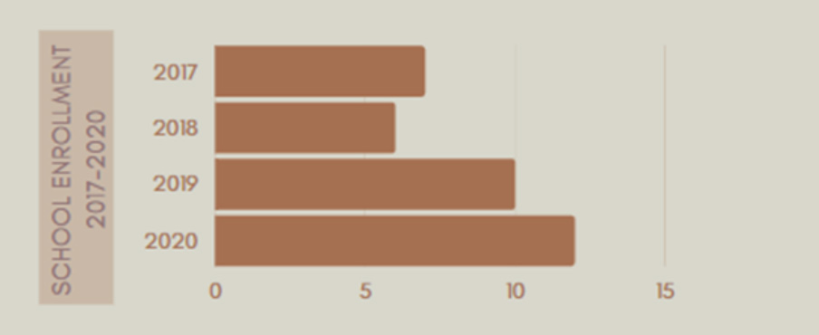
Education4
Port Lions School
Kodiak Island Borough School District
Transportation – Only accessible by boat or plane
Air
State of Alaska-owned 2,600 foot gravel airstrip; Daily flights between Port Lions and Kodiak via Island Air Service.
Water
Small boat harbor, may be used by seaplanes; 68 boat slips; Boat harbor partially rebuilt in 2011.
Recently built deep water city dock to accommodate large ships; Alaska Marine Highway ferries serve Port Lions twice/week from May to October, and twice a month November to April.
Access to Kodiak Road System at Anton Larsen Bay during non-winter months.
Employment & Businesses
17 Business License Holders
$42,917 Median household income
13.9% Unemployed
5% Bed Tax
12.9% Living below poverty
0% Sales tax
10.75 Property tax mills
Local government and utilities are the main employers in Port Lions. There is some employment from sport fishing, _ hunting guide services, and commercial fishing. In the 1970s and 1980s, commercial fishing and lumber industries fueled a thriving community in Port Lions. However, in recent decades the community has increasingly struggled to provide year-round employment for its residents due to a decline in fish prices.
Community Energy Sources & Use
Utility Provider: Kodiak Electric Association
Sources of Energy: Hydropower, Wind,Diesel
Gas Vendor: Kizhuyak Oil Sales
Bank Fuel Capacity: NVPL 90,600 gallons; KEA 1100 gallons
| Electric Customers | Annual Fuel UsE (Gallons) |
| 135 Residential | N/A Electric |
| 15 Community Facilities | 97,391 Space Heating |
| 26,049 Transportation |
Community Energy Priorities
- Maintenance and efficiency of public buildings
a. Funding for energy audits and retrofits on community buildings
b. Pursue RACEE Round 2 funding (in progress as of May 2020) - Maintenance and efficiency of residential buildings
a. Feasibility of energy efficiency upgrades to residential buildings
b. Pursue RACEE Round 2 funding (in progress as of May 2020) - Maintenance and efficiency of commercial buildings
a. Feasibility of energy efficiency upgrades to commercial buildings
b. Pursue RACEE Round 2 funding (in progress as of May 2020) - Maintenance and efficiency of water utilities
a. Conduct system-wide energy audit - Maintenance and efficiency of community transportation infrastructure
a. Improve reliability of cost-effective transportation option – improve transportation options for elders - Develop local energy generation
a. Reactivate Tribal Energy Dept. – Hire energy coordinator - Broadband Internet Infrastructure
a. Aleutian/Kodiak fiber optic cable installation
Capital Improvement Projects (CIP) List FY21
| Estimated Cost | Project Name |
| $120,000 | Loader |
| $700,000 | Broadband Internet Tech. |
| $1,200,000 | Road Upgrade |
| $35,000 | Insulated Fire Truck Garage |
| $50,000 | Disaster Emergency Preparedness |
| $50,000 | Landfill Bulldozer |
References
1. https://www.census.gov/
2. https://www.bia.gov/
3. https://www.census.gov/
4. https://education.alaska.gov/